Tropical Cyclones Luis and Maymay and Enhanced Southwest Monsoon - Situation Report #1 (August 7, 2026)
August 7, 2026
Situation Overview
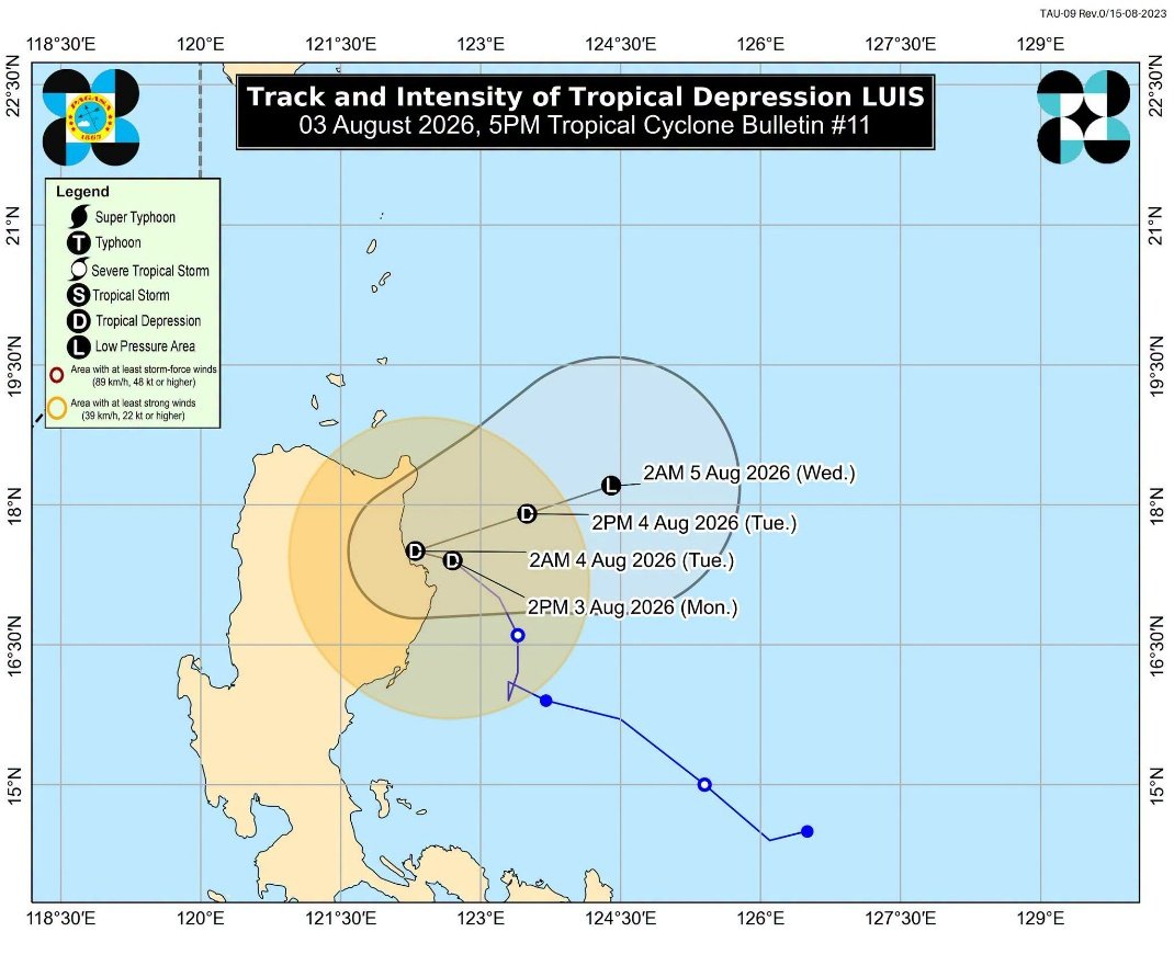
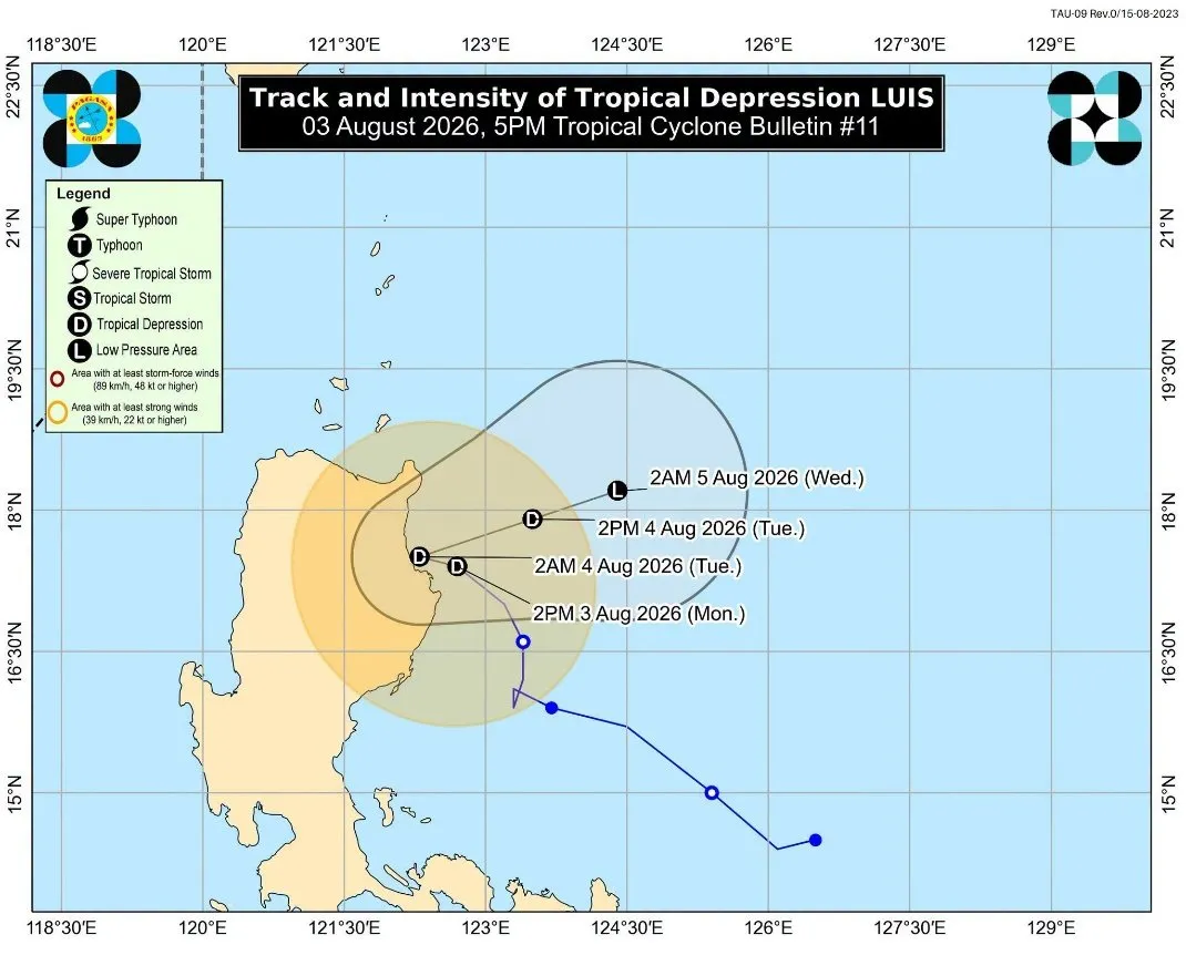
Figure 1. Track and Intensity of Tropical Depression Luis 30 minutes before it made landfall.
Tropical Cyclone LUIS. On 01 August 2026 at 5:00 PM, a Low Pressure Area (LPA 07f) was being monitored within the Philippine Area of Responsibility (PAR), with a high likelihood of developing into a Tropical Depression (TD). At 8:00 PM on the same day, LPA 07f, located east of Infanta, Quezon, developed into Tropical Depression LUIS. On 02 August 2026 at 10:00 AM, TD LUIS maintained its strength while moving northwestward over the waters of Quezon Province. On 03 August 2026 at 5:30 PM, TD LUIS made landfall over Maconacon, Isabela. By 8:00 PM, LUIS had weakened into a Low Pressure Area.
The highest Tropical Cyclone Wind Signal (TCWS) raised for LUIS was TCWS No. 1, covering the Polillo Islands, Camarines Norte, Catanduanes, Camarines Sur, southern, central, and eastern portions of Cagayan, Isabela, Quirino, northern portion of Aurora, eastern and southern portions of Apayao, eastern portion of Kalinga, eastern portion of Mountain Province, and eastern portion of Ifugao.
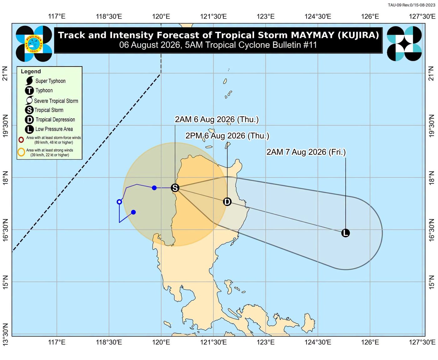
Figure 2. Track and Intensity of Tropical Storm Maymay as it made landfall over Magsingal, Ilocos Sur.
Tropical Cyclone MAYMAY. On 04 August 2026, an LPA located approximately 180 kilometers west of Bacnotan, La Union, developed into Tropical Depression MAYMAY. On 05 August 2026, MAYMAY intensified into a Tropical Storm. At 2:00 AM on 06 August 2026, Tropical Storm MAYMAY made landfall over Magsingal, Ilocos Sur. By 8:00 AM, MAYMAY had weakened into a Tropical Depression. On 07 August 2026 at 2:00 AM, MAYMAY (I.N. KUJIRA) further weakened into a Low Pressure Area and was assessed as unlikely to redevelop into a Tropical Depression.
The highest Tropical Cyclone Wind Signal (TCWS) raised for MAYMAY was TCWS No. 2, covering Ilocos Norte, Ilocos Sur, northern and central portions of La Union, northwestern Pangasinan, southwestern Abra, western Mountain Province, and northwestern Benguet.
TCWS No. 1 was also raised over the rest of La Union, rest of Pangasinan, Cagayan, rest of Apayao, rest of Abra, Kalinga, rest of Mountain Province, rest of Benguet, Ifugao, Nueva Vizcaya, northern portion of Nueva Ecija, northern Zambales, northern Tarlac, Isabela, and Quirino.
Meanwhile, Typhoon Dolphin, which was located outside the Philippine Area of Responsibility (PAR), approximately 925 kilometers northeast of extreme Northern Luzon, was enhancing or “pulling” the Southwest Monsoon (Habagat). As a result, widespread rains were being experienced across Luzon and parts of the Visayas, contributing to continued rainfall, caused flooding, and heightened risks of landslides and other rain-induced hazards in affected areas.
In Batanes and the Babuyan Islands, cloudy skies with scattered rains and thunderstorms were being experienced due to the trough of Typhoon Dolphin. Meanwhile, Mindanao was experiencing partly cloudy to cloudy skies with isolated rainshowers or thunderstorms brought about by localized thunderstorms.
Sources: DOST-PAGASA
Affected Populations
A total of 38,077 families or 127,137 persons were affected across six regions: Ilocos Region, Cagayan Valley Region, Cordillera Administrative Region (CAR), Central Luzon, Bicol Region, and Zamboanga Peninsula. Of these, 1,870 families or 5,883 persons were served inside 37 evacuation centers (ECs), while 458 families or 1,522 persons were served outside evacuation centers.
Three (3) rain-induced landslide incidents were reported:
La Union: A landslide occurred along a barangay road, affecting one (1) household.
Benguet: At around 9:00 AM on 06 August 2026, a landslide occurred along Shilan, La Trinidad, Benguet, partially burying a restaurant. The landslide consisted of mud, rocks, and debris and was triggered by persistent heavy rains. Search, rescue, and retrieval operations were immediately conducted by the Benguet Police Provincial Office, Municipal Disaster Risk Reduction and Management Office (MDRRMO), Shilan Barangay Disaster Risk Reduction and Management Office (BDRRMO), La Trinidad Bureau of Fire Protection (BFP), Municipal Health Unit (MHU), and the Local Government Unit (LGU) of La Trinidad. One (1) injured victim was rescued and brought to the hospital, while two (2) fatalities were retrieved at around 11:00 AM.
Rizal: At around 12:20 PM on 05 August 2026, a rockslide occurred in Sitio Wawa, Barangay San Rafael, Rodriguez, Rizal, resulting in the deaths of two (2) individuals.
Overall, four (4) deaths and one (1) injury were reported, with two fatalities recorded in the Cordillera Administrative Region and two in CALABARZON.
Also, 236 road sections and 18 bridges were affected. Of these, 30 road sections and one (1) bridge remain impassable.
Meanwhile, a total of 396 passengers from CALABARZON and the Bicol Region were reported stranded because of the weather disturbances.
According to ICRED, our regional partner, significant flooding, road obstructions, power interruptions, and livelihood disruptions were monitored in La Union and Ilocos Sur because of the recent weather disturbances.
In Bauang, La Union, ten (10) barangays were reported to have experienced flooding. Most of the affected areas are rice fields with newly planted rice crops, raising concerns about potential crop losses. In Sto. Tomas, flooding was reported in 3 barangays, while flooding was also monitored in 5 barangays in San Fernando. Flooding is also monitored in Naguilian, Agoo, and San Juan. Some rivers have also overflowed, including the Baroro River in San Juan.
Class and work suspensions were announced across the province. Power interruptions were also reported in several areas, including San Fernando, Agoo, Naguilian, and Bauang.
The weather disturbances have significantly affected artisanal fisherfolk families in Sto. Tomas, Agoo, Aringay, Bauang, San Fernando, Balaoan, Luna, Bacnotan, and San Juan. For six (6) consecutive days, fisherfolk were unable to go fishing due to strong waves and unsafe sea conditions. Estimated income losses ranged from PHP 150–300 per day, or approximately PHP 900–1,800 over six days, reducing household income and the ability of affected families to meet their food needs. As of the latest monitoring, sea conditions remained rough, continuing to prevent fisherfolk from fishing.
Farmers were likewise affected, particularly vegetable farmers in Naguilian, where strong winds and heavy rainfall damaged crops. Flooding in rice paddies has also not yet subsided, placing newly planted rice crops at risk.
In Ilocos Sur, road obstructions were reported in Quirino, Suyo, Gregorio del Pilar, and Candon City due to landslides, rockslides, and flooding. Flooding was also monitored in Vigan City and Tagudin.
Fisherfolk families in Santa, Caoayan, and Magsingal were among those significantly affected. For seven (7) days, fisherfolk were unable to fish because of strong waves and unsafe sea conditions. Estimated income losses ranged from PHP 200–900 per day, equivalent to approximately PHP 1,400–6,300 over seven days. The continued strong waves have prevented fisherfolk from resuming their regular fishing activities, resulting in reduced household income and food access.
In Miramar, Magsingal, fisherfolk were unable to fish for at least three (3) days, resulting in an estimated income loss of PHP 1,000–1,500 per day, or approximately PHP 3,000–4,500 in total. In Alangan, Magsingal, fisherfolk reportedly lost approximately PHP 5,000, equivalent to around PHP 1,000 per day for five days, due to their inability to fish.
The prolonged disruption of fishing activities, combined with flooding and damage to agricultural areas, has reduced the income and food security of affected households. Continued monitoring is necessary, particularly in communities dependent on fishing and agriculture, as sea conditions and flooding remain a constraint to the recovery of livelihoods.
Sources: NDRRMC, ICRED
Emergency Response Efforts
CDRC along with the affected regional partner, continues to monitor the situation and has commenced issuing situation reports.
Coordination
Regional Partner
Contacts
Glenn Latoza – 09662343358