Tropical Cyclones Luis and Maymay and Enhanced Southwest Monsoon - Situation Report #2 (August 9, 2026)
August 9, 2026
Situation Overview
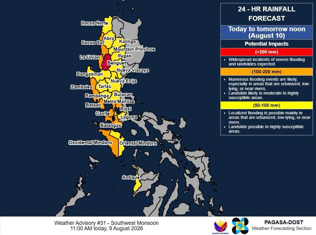
Figure 1. 24-hour Rainfall Forecast from DOST-PAGASA.
According to DOST-PAGASA, the Southwest Monsoon (Habagat) continues to bring heavy and persistent rainfall over large parts of Luzon and portions of the Visayas. The Habagat has been further enhanced by the recent passage of Tropical Cyclones LUIS and MAYMAY, as well as Typhoon DOLPHIN, which, despite being outside the Philippine Area of Responsibility (PAR), contributed to the strengthening of the southwest monsoon. The enhanced monsoon has resulted in widespread flooding, landslides, rising river and dam water levels, and disruptions to transportation and other essential services.
As of 09 August, PAGASA continued to monitor the Southwest Monsoon and issued Weather Advisory No. 30, warning of continued heavy rainfall.
Date | >200 mm | 100-200 mm | 50-100 mm |
|---|---|---|---|
August 9 | Ilocos Sur and Benguet | La Union, Abra, Zambales, Bataan, Metro Manila, Rizal, Cavite, Batangas, and Occidental Mindoro | Ilocos Norte, Pangasinan, Apayao, Kalinga, Mountain Province, Ifugao, Nueva Vizcaya, Tarlac, Nueva Ecija, Pampanga, Bulacan, Laguna, Oriental Mindoro, and Antique |
August 10 | - | Ilocos Sur, La Union, Benguet, Zambales, Bataan, and Occidental Mindoro | Ilocos Norte, Pangasinan, Abra, Kalinga, Mountain Province, Ifugao, Nueva Vizcaya, Tarlac, Nueva Ecija, Pampanga, Bulacan, Metro Manila, Rizal, Cavite, Batangas, Oriental Mindoro, and Antique |
August 11 | - | Zambales, Bataan and Occidental Mindoro | La Union, Ilocos Sur, Pangasinan, Abra, Benguet, Tarlac, Pampanga, Nueva Ecija, Cavite, Batangas, and Antique |
The La Mesa Dam water level reached 79.82 meters at around 11:10 AM on 09 August, exceeding its 79.50-meter critical level and approaching its 80.15-meter spilling level. The dam has no floodgates, and once the spilling level is reached, excess water will flow toward the Tullahan River. The Marikina River also reached over 15 meters on 08 August, triggering the second alarm, and 16.2 meters at around 11:10AM on 09 August, triggering the second alarm level. The rising water level poses a continuing flood risk to low-lying and riverside communities in Quezon City, Pasig City, and Marikina City.
The continuing rainfall comes after several areas of Luzon experienced substantial rainfall from MAYMAY and the enhanced Habagat. According to PAGASA data, Baguio City recorded 355.2 mm of rainfall from 05 August to 07 August, equivalent to approximately 11 days' worth of August rainfall. The following areas also and a week’s rain:
Area | Rainfall | |
|---|---|---|
Recorded more than a week’s August rain in just 48 hours | Dagupan City, Pangasinan | 164.8 mm |
Tanauan City, Batangas | 76.3 mm | |
Tuguegarao City, Cagayan | 58.0 mm | |
Recorded a week’s rain in 48 hours | Iba, Zambales | 191.7 mm |
Subic, Zambales | 186.5 mm | |
Sinait, Ilocos Sur | 129.2 mm | |
Cavite City | 102.7 mm | |
- | Abucay Station, Bataan | 171.9 mm |
Recorded two weeks’ rain | NAIA Station in Pasay | 89.0 mm |
Recorded about 4 days of August rain | Science Garden Station in Quezon City | 73.0 mm |
While the rainfall has helped ease drought conditions in some areas, the accumulated rainfall has increased the risk of flooding, landslides, and further disruption to communities and livelihoods, particularly in areas that have already experienced significant rainfall in recent days.
Sources: DOST-PAGASA, ABS-CBN, DZMM Radyo Patrol 630
Analysis of the Current Situation
The current flooding and related impacts should be understood in the context of the enhanced Southwest Monsoon rather than being attributed solely to the recent tropical cyclones. Tropical Cyclones LUIS and MAYMAY were relatively weak systems and, on their own, were not expected to produce the volume and persistence of rainfall currently being experienced in many parts of Luzon. Instead, the recent weather events helped contribute to an already active Southwest Monsoon, while Typhoon DOLPHIN, although outside the Philippine Area of Responsibility (PAR), further enhanced the Southwest Monsoon and strengthened the southwest monsoon flow affecting the country.
The unusually high volume of rainfall is also occurring after several areas experienced prolonged periods of extreme heat and high heat index conditions prior to the onset of the rains. The transition from intense heat to a highly moisture-laden monsoon environment has contributed to episodes of intense and persistent rainfall, while the enhanced Southwest Monsoon associated with DOLPHIN has further sustained the inflow of moisture toward Luzon and parts of the Visayas. The combination of heavy rainfall and significant antecedent rainfall has resulted in rapid accumulation of water, river and dam level increases, flooding, and rain-induced landslides, particularly in low-lying, riverside, and landslide-prone communities.
The impacts are particularly significant for vulnerable and low-income communities, where households often live in flood-prone or environmentally exposed areas and have limited capacity to absorb repeated shocks. Prolonged flooding can lead to displacement, damage to houses and household assets, interruption of access to food, water, health services, and transportation, and increased exposure to health and protection risks. The disruption of roads, bridges, markets, agricultural activities, and fishing also has direct economic consequences. Farmers and fisherfolk are losing income as fields remain flooded and strong waves prevent fishing, while damaged infrastructure and disrupted transport can increase the cost and difficulty of accessing essential goods and services.
The situation therefore represents a compounding hazard scenario, where the effects of the recent tropical cyclones, enhanced Southwest Monsoon, accumulated rainfall, and continued rainfall are interacting with existing vulnerabilities. Even as the tropical cyclones have weakened or moved away, the risk remains elevated because the ground is already saturated, rivers and dams are at high levels, and additional heavy rainfall is forecast in several highly exposed areas. This means that communities may continue to experience flooding, landslides, livelihood losses, and access constraints even in the absence of a strong tropical cyclone directly making landfall.
Affected Populations
As of the latest monitoring, a total of 98,246 families or 336,366 persons were affected across 788 barangays in the Ilocos Region, Cagayan Valley Region, Cordillera Administrative Region (CAR), Central Luzon, CALABARZON, MIMAROPA, Bicol Region, Western Visayas, and Zamboanga Peninsula. Of these, 2,854 families or 8,859 persons were served inside 113 evacuation centers, while 1,221 families or 3,797 persons were served outside evacuation centers.
Another eight (8) rain-induced landslide incidents were reported:
Cavite: Two separate landslides occurred in General Mariano Alvarez, partially damaging two (2) houses.
Rizal: A landslide in Antipolo, prompting the safe evacuation of two (2) families or 12 individuals. Clearing operations are ongoing. Three separate landslides were also reported in Taytay, resulting in two (2) partially damaged houses and one (1) totally damaged house.
La Union: Two separate landslides occurred in Naguilian. One occurred along the barangay road leading to the Barangay Hall of Cabaritan Norte, while the other affected one (1) household.
Overall, six (6) deaths and seven (7) injuries were reported. The fatalities were recorded in the Cordillera Administrative Region (two), CALABARZON (two), and Ilocos Region (two).
A total of 360 road sections and 20 bridges were affected. Of these, 43 road sections and two (2) bridges remain impassable, further restricting access to affected communities.
A total of 135 houses were reported damaged across six regions—Ilocos Region, CAR, Central Luzon, CALABARZON, MIMAROPA, and Western Visayas. Of these, 127 houses were partially damaged and eight (8) were totally damaged.
In the Ilocos Region, infrastructure damage was estimated at approximately PHP 105 million, involving 18 infrastructure facilities, particularly roads, across 12 municipalities in Pangasinan.
Sources: NDRRMC
Reported Impacts
La Union & Ilocos Sur
According to ICRED, our regional partner, significant flooding, road obstructions, power interruptions, and livelihood disruptions were monitored in La Union and Ilocos Sur due to the recent weather disturbances.
In Bauang, La Union, ten (10) barangays were reported to have experienced flooding. Most of the affected areas are rice fields with newly planted rice crops, raising concerns about potential crop losses. In Sto. Tomas, flooding was reported in three (3) barangays, while flooding was also monitored in five (5) barangays in San Fernando. Flooding was likewise reported in Naguilian, Agoo, and San Juan. Some rivers also overflowed, including the Baroro River in San Juan.
Class and work suspensions were announced across the province. Power interruptions were also reported in several areas, including San Fernando, Agoo, Naguilian, and Bauang.
The weather disturbances have significantly affected artisanal fisherfolk families in Sto. Tomas, Agoo, Aringay, Bauang, San Fernando, Balaoan, Luna, Bacnotan, and San Juan. For six (6) consecutive days, fisherfolk were unable to go fishing due to strong waves and unsafe sea conditions. Estimated income losses ranged from PHP 150–300 per day, or approximately PHP 900–1,800 over six days, reducing household income and the ability of affected families to meet their food needs. As of the latest monitoring, sea conditions remained rough, continuing to prevent fisherfolk from fishing.
Farmers were likewise affected, particularly vegetable farmers in Naguilian, where strong winds and heavy rainfall damaged crops. Flooding in rice paddies has also not yet subsided, placing newly planted rice crops at risk.
In Ilocos Sur, road obstructions were reported in Quirino, Suyo, Gregorio del Pilar, and Candon City due to landslides, rockslides, and flooding. Flooding was also monitored in Vigan City and Tagudin.
Fisherfolk families in Santa, Caoayan, and Magsingal were among those significantly affected. For seven (7) days, fisherfolk were unable to fish because of strong waves and unsafe sea conditions. Estimated income losses ranged from PHP 200–900 per day, equivalent to approximately PHP 1,400–6,300 over seven days. The continued strong waves have prevented fisherfolk from resuming their regular fishing activities, resulting in reduced household income and food access.
In Miramar, Magsingal, fisherfolk were unable to fish for at least three (3) days, resulting in an estimated income loss of PHP 1,000–1,500 per day, or approximately PHP 3,000–4,500 in total. In Alangan, Magsingal, fisherfolk reportedly lost approximately PHP 5,000, equivalent to around PHP 1,000 per day for five days, due to their inability to fish.
The prolonged disruption of fishing activities, combined with flooding and damage to agricultural areas, has reduced the income and food security of affected households. Continued monitoring is necessary, particularly in communities dependent on fishing and agriculture, as sea conditions and flooding remain constraints to livelihood recovery.
Quezon City – Community-Level Reports
Based on monitoring by the Disaster Preparedness Committees (DPCs) in Barangay Bagong Silangan, Quezon City, flooding has also affected low-lying communities along the river and other flood-prone areas.
Village of Tumana/Greenland: Approximately 200 families were reported to be affected. Houses located in the lower-lying portions of the community have already been inundated.
Village of Tagumpay: Approximately 160 families were affected. Residents living near the San Mateo River have started evacuating as floodwaters entered their houses.
Village of Bakal: Approximately 80 families were affected. Houses located near the river have already been inundated.
These community-level reports indicate that low-lying and riverside households in Bagong Silangan are experiencing direct flooding impacts, with some families already evacuating due to rising water levels. The situation highlights the continued vulnerability of households living along waterways and in flood-prone areas, particularly as heavy rainfall is expected to persist.
Conclusion
The reported impacts from ICRED and the Bagong Silangan DPCs demonstrate that the prolonged rainfall is affecting both livelihoods and household safety, with impacts extending from agricultural and fishing communities in Northern Luzon to highly exposed urban communities in Metro Manila.
Sources: Ilocos Center for Research, Empowerment and Development, Inc. (Regional Partner); Disaster Preparedness Committees in Quezon City – Bakal, Tumana+Bona, Tagumpay
Emergency Response Efforts
CDRC along with the affected Regional Partners and Disaster Preparedness Committees continues to monitor the situation and has commenced issuing situation reports.
Coordination
Regional Partners and Disaster Preparedness Committees
Contacts
Glenn Latoza – 09662343358