Tropical Cyclones Luis and Maymay and Enhanced Southwest Monsoon - Situation Report #3 (August 17, 2026)
August 17, 2026
Situation Overview
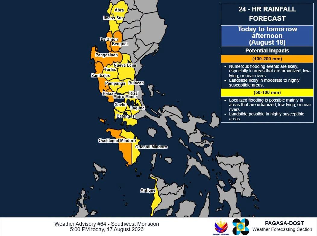
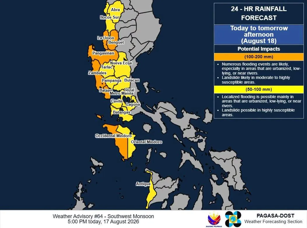
Figure 1. 24-hour Rainfall Forecast from DOST-PAGASA.
According to PAGASA, a Low Pressure Area (LPA) located approximately 1,160 km east of Northern Luzon is enhancing the Southwest Monsoon (Habagat), resulting in continued rainfall over Luzon and the Visayas. The persistent rains began following the effects of Tropical Cyclone Luis and were further sustained by Tropical Cyclone Maymay.
Although there was a brief improvement in weather conditions over the weekend, moderate to heavy rainfall resumed during the early morning of August 17, 2026. The rainfall temporarily weakened for several minutes at a time but repeatedly intensified, with rainfall becoming particularly heavy and continuous around 9:00–10:00 AM.
The prolonged and intense rainfall has caused flooding in several areas, including Quezon City. In some affected communities, floodwaters have reached waist- to knee-deep levels, with rapidly flowing water posing additional risks to residents, particularly those in low-lying and flood-prone areas. Continued rainfall is also increasing the risk of further flooding and displacement.
As of 17 August, PAGASA continued to monitor the Southwest Monsoon and issued Weather Advisory No. 64, warning of continued heavy rainfall.
Date | 100-200 mm | 50-100 mm |
|---|---|---|
August 18 | Benguet, La Union, Pangasinan, Zambales, and Occidental Mindoro | Ilocos Sur, Abra, Tarlac, Pampanga, Bulacan, Nueva Ecija, Metro Manila, Cavite, Laguna, Batangas, Rizal, Oriental Mindoro, and Antique |
August 19 | Benguet, La Union, Pangasinan, Zambales, Bataan, and Occidental Mindoro | Ilocos Sur, Tarlac, Pampanga, Bulacan, Nueva Ecija, Metro Manila, Cavite, Laguna, Batangas, Rizal, Oriental Mindoro, and Antique |
August 20 | Zambales, Bataan, and Occidental Mindoro | Ilocos Sur, La Union, Benguet, Pangasinan, Tarlac, Pampanga, Bulacan, Metro Manila, Rizal, Cavite, Laguna, and Batangas |
Sources: DOST-PAGASA
Analysis of the Current Situation
The continuing influence of the Southwest Monsoon, enhanced by the Low Pressure Area east of Northern Luzon, has resulted in persistent moderate to heavy rainfall over Luzon and the Visayas. While affected communities were able to cope with the flooding last week because floodwaters were gradually subsiding between periods of rain, the situation has become more critical today. August 17 has brought the heaviest and most prolonged rainfall experienced so far, with only brief periods of reduced rainfall before intensifying again.
The prolonged and intense rainfall has caused water levels to rise rapidly in several areas. The San Mateo River has significantly risen and has already overflowed, contributing to worsening flooding in downstream and low-lying communities. In Quezon City, floodwaters have reached knee- to waist-deep levels in some areas, with rapidly flowing water posing additional risks to residents. The continued rainfall and overflowing waterways increase the likelihood of further flooding, displacement, and difficulty in accessing affected communities.
The prolonged rains have also disrupted the livelihoods of vulnerable households. Construction workers have been unable to work since the previous week, while pedicab drivers have been unable to operate due to flooded roads. Vegetable growers have also experienced potential livelihood and food-production losses as their vegetable plots have been submerged. These disruptions may further reduce the ability of affected families to meet their immediate food and other basic needs.
As of the reported assessments on August 17, an estimated 2,000 families have been affected across Barangay Talayan, Barangay Tatalon, Barangay Doña Imelda, and NIA Road in Diliman. The situation at the evacuation center is particularly concerning as floodwater has entered the tents of families who were already displaced by a previous fire incident, potentially exposing them to further displacement, loss of belongings, and protection risks.
Given the increased intensity and duration of rainfall today, the situation requires closer monitoring and timely action. The combination of saturated areas, rising river levels, and the overflow of the San Mateo River may result in further increases in flood depth and the expansion of affected areas. Continued coordination with barangay authorities and other responders is necessary, particularly for early warning dissemination, evacuation of households in high-risk areas, and monitoring of families whose livelihoods and temporary shelters have been affected.
Affected Populations
As of the latest monitoring, a total of 1,429,369 families or 4,996,687 persons were affected across 4,134 barangays in the Ilocos Region, Cagayan Valley Region, Cordillera Administrative Region (CAR), Central Luzon, National Capital Region, CALABARZON, MIMAROPA, Bicol Region, Western Visayas, and Zamboanga Peninsula. Of these, 7,562 families or 26,274 persons were served inside 354 evacuation centers, while 26,604 families or 78,324 persons were served outside evacuation centers.
Overall, 23 deaths and 17 injuries were reported. The fatalities were recorded in the Cordillera Administrative Region (15), CALABARZON (7), and Ilocos Region (1).
A total of 774 road sections and 39 bridges were affected. Of these, 114 road sections and 11 bridges remain impassable, further restricting access to affected communities.
A total of 1,838 houses were reported damaged across six regions—Ilocos Region, CAR, Central Luzon, CALABARZON, MIMAROPA, and Western Visayas. Of these, 1,667 houses were partially damaged and 171 were totally damaged.
Sources: NDRRMC
Reported Impacts
La Union and Ilocos Sur
La Union and Ilocos Sur continue to experience heavy rainfall due to the prevailing weather disturbance. As a result, fisherfolk remain unable to resume fishing activities because sea conditions continue to be unsafe. The prolonged disruption of fishing is affecting the daily income and food access of fishing-dependent households.
Quezon City
Based on monitoring by the Disaster Preparedness Committees (DPCs) in Barangay Bagong Silangan, Quezon City, floodwaters had subsided during the weekend, allowing communities to temporarily cope with the situation. They were able to go back to their houses for a while. However, the intense and prolonged rainfall throughout August 17 caused flooding to return in several areas of Quezon City, including Barangay Bagong Silangan. As a predominantly low-lying and flood-prone community, Bagong Silangan remains highly exposed to flooding, particularly among households located near waterways and other low-lying areas.
As of August 17, 2026, the following impacts have been reported in Quezon City:
Affected Area | Estimated Affected Families | Reported Impact |
|---|---|---|
Barangay Talayan | 400 | Flooding reported in the area, affecting households and access within the community. |
NIA Road, Diliman | 300 | Floodwater entered the tents of families who were already displaced by a previous fire incident, affecting their temporary shelter. |
Barangay Tatalon | 900 | Flooding affected households in the community. |
Barangay Doña Imelda | 400 | Flooding affected households in the community. |
Overall, an estimated 2,000 families have been reported affected across the four monitored areas. The number of affected households may increase if the rainfall persists, particularly in low-lying and riverside communities.
The prolonged rainfall is also contributing to broader livelihood disruption. Households dependent on daily wage employment, informal transport, and vegetable farming are experiencing reduced or lost income at a time when flooding is also affecting mobility and access to basic needs. The overflow of the San Mateo River and continued rise in water levels further increase the risk of additional household flooding and displacement.
The situation at the Manila Seedling Evacuation Center is of particular concern, as families already displaced by a previous fire are now experiencing flooding inside their temporary tents. This may result in further displacement and increased needs for temporary shelter, essential household items, food, and other basic assistance.
Tarlac
Communities of Aeta in Capas, Tarlac continue to experience heavy rainfall due to the Southwest Monsoon. The persistent rains have triggered flash floods and landslides, posing risks to residents and causing impacts on homes, livelihoods, and access to basic needs.
At present, an estimated 635 families from three communities require immediate assistance:
Sapang Kawayan – 160 families
Binyayan – 200 families
Mabanayucan – 265 families
The situation of these communities is further compounded by an ongoing threat of displacement from their ancestral lands, which are reportedly located within areas covered by the planned US-led Pax Silica initiative and developments in and around New Clark City.
The affected Aeta communities are therefore facing two intersecting crises: the immediate impacts of the disaster and the continuing threat to their ancestral land and displacement. The combination of disaster-related impacts, livelihood disruption, and insecurity over their land increases their vulnerability and may limit their capacity to recover from the current situation. Continued monitoring and timely humanitarian assistance are needed, particularly for households affected by flooding and landslides and those with limited access to basic necessities.
Sources: Ilocos Center for Research, Empowerment and Development, Inc. (Regional Partner); Alay Bayan-Luson, Inc. (ABI); Disaster Preparedness Committees in Quezon City – Bakal, Tumana+Bona, Tagumpay; People’s Organization
Emergency Response Efforts
CDRC along with the affected Regional Partners and Disaster Preparedness Committees continues to monitor the situation and has commenced issuing situation reports.
Coordination
Regional Partners and Disaster Preparedness Committees
Contacts
Glenn Latoza – 09662343358